South Cumberland State Park Tennessee is not a single park. It’s a system of 11 distinct natural areas spread across the Cumberland Plateau, connected by one of the most impressive trail networks in the Southeast. More than 125 miles of trail run through gorges, past waterfalls, across sandstone bluffs, and into backcountry that most Tennessee visitors never find.
If you’re staying at The Getaway on Ranger Creek, you’re near it all. Several of the park’s main areas are within 30 minutes of the property. Some are closer than that.
South Cumberland State Park at a Glance
- 11 distinct natural areas spread across the Cumberland Plateau
- Over 125 miles of trail
- Closest entrance from the property: 12 minutes (Greeter Falls / Grundy Forest)
- All major areas within 30 minutes of The Getaway on Ranger Creek
- Free admission; dogs welcome on leash
- Best for full waterfall flow: spring and after heavy rain
What Is South Cumberland State Park Tennessee?
The park system was established to protect some of the most geologically significant land on the plateau. The Cumberland Plateau sits at roughly 2,000 feet, and over millions of years, water carved the sandstone into gorges, crevices, and canyon systems that run deep into the earth. South Cumberland is where most of that dramatic terrain is concentrated.
The 11 areas range from short, family-friendly waterfall walks to serious backcountry routes with multi-day camping. They’re managed together under one park system but spread across several counties, which means you need a little planning to make the most of a visit. This guide covers the areas closest to the property and the ones worth prioritizing on a weekend trip.
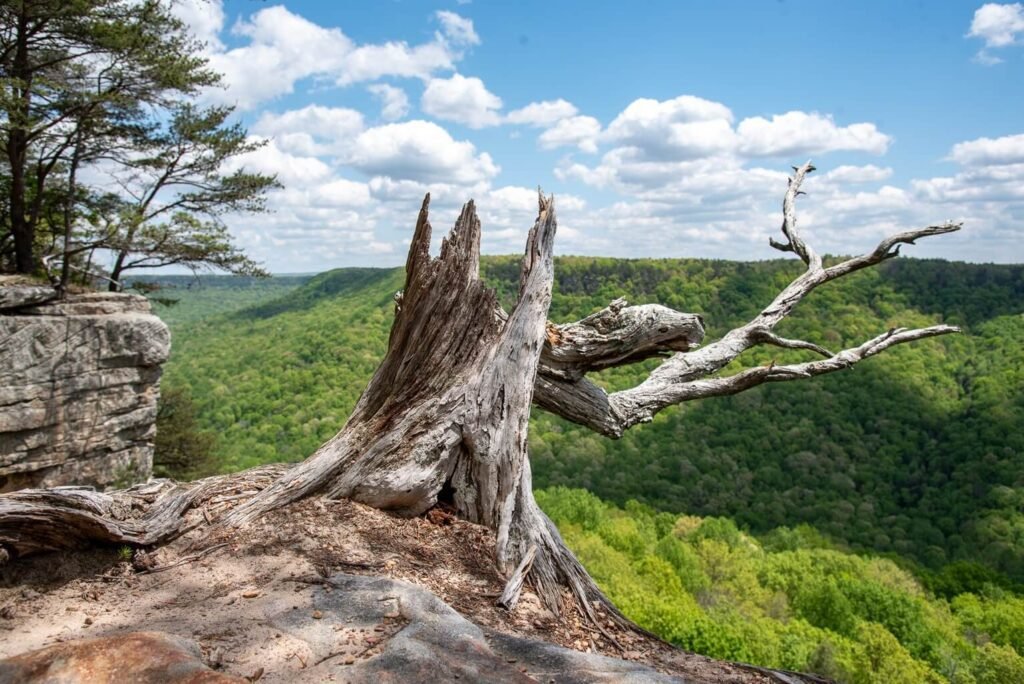
Greeter Falls and Grundy Forest
The easiest starting point, and one of the best. Greeter Falls is approximately 12 minutes from the property, and the trail system connects two waterfalls through Grundy Forest State Natural Area.
The upper falls drops about 15 feet into a clear pool. Another quarter mile down the trail, the lower falls plunges 50 feet into a deep swimming hole ringed by sandstone walls. The full loop runs around three miles. It’s manageable for most fitness levels and genuinely rewarding at every turn.
Grundy Forest itself is worth a deeper look. Old-growth hemlocks, rhododendron tunnels, mossy boulders. The forest has a density and age to it that feels different from most Tennessee trail systems. Our FAQ breaks down the Grundy Forest hike with drive times and what to expect.
A seasonal note: waterfall flow varies significantly with rainfall. After a dry stretch, both falls can drop considerably. Spring and after heavy rain are the best times for full flow. That said, the forest is worth the walk in any conditions.
Foster Falls
Foster Falls sits about 28 minutes from the property in the opposite direction and deserves more attention than it usually gets. A 60-foot waterfall drops into a wide pool with a sandy bottom, and the approach trail is short enough that the payoff feels almost unfair. Swimming is popular in warmer months. The area also has a small campground for those who want to stay closer to the trail.
Same seasonal caveat applies: flow is best after rain. In dry stretches the falls can thin out, but the pool and the surrounding gorge are worth seeing regardless.
The Fiery Gizzard Trail
The Fiery Gizzard Trail is one of the most celebrated hikes in Tennessee, and it runs through the heart of South Cumberland State Park. The full trail covers about 12 miles one way, connecting Grundy Forest near Tracy City to Foster Falls. Along the way: multiple smaller waterfalls, narrow gorges, sandstone bluffs, and a terrain that shifts constantly.
Most visitors don’t do the full out-and-back in a single day. The more common approach is to hike in from one end, go as far as feels right, and turn around. The first few miles from either trailhead are the most dramatic. Dog Hole Falls and Blue Hole Falls are both within reach on a half-day hike from the Grundy Forest entrance.
If you want the full trail, plan for a shuttle or a long day with an early start.
Stone Door and Savage Gulf
Stone Door is one of the more extraordinary geological features in the park system. A 150-foot crack in the sandstone plateau, wide enough to walk through, that drops into the Savage Gulf below. The trail from the Stone Door Ranger Station is about a mile each way and gives you both the overlook and access through the crevice itself.
Savage Gulf extends below as one of the largest gorge systems on the plateau. The backcountry trail network inside the gulf covers miles of remote terrain with primitive camping available for those who want to spend a night down in it. The gulf was managed for years as Savage Gulf State Natural Area before being designated its own state park in 2022. We wrote a dedicated guide to Savage Gulf State Park and the Stone Door trail.
Where Should You Stay When Visiting South Cumberland State Park Tennessee?
The trail systems in South Cumberland don’t have to be a day-trip destination. They work best when you have somewhere comfortable to come back to: a real bed, a hot shower, a fire pit for the evening.
The Getaway on Ranger Creek puts you within 30 minutes of every area mentioned in this post. The property has five units: the Geodesic Glamping Dome, the Scandinavian Cabin, the Glamping Tent with Deck, the Boho Cabin, and the Cozy Spruce Cabin. You can hike hard during the day and sleep well at night.
For trail maps and current conditions, the Tennessee State Parks website is the most reliable source: tnstateparks.com.
Book your stay at thegetawayon.com.